In The News
Cap And Connect
In 1956, President Dwight Eisenhower signed the Federal-Aid Highway Act, setting into motion the birth of America’s Interstate Highway System. During the following decade, more than 53,000 km (33,000 mi) of interstate highway were constructed using billions of federal, state, and local dollars. This system is considered a modern engineering marvel, estimated by the U.S. Department of Transportation (DOT) to be equal to 700 mounds of material equal in size to the largest Egyptian pyramids. Unfortunately, for all the engineering might behind the construction of the interstate system, it is not without its blemishes. During its construction, it is estimated that more than 450,000 families were displaced, many of whom were in economically disadvantaged urban communities of color.
In recent decades, there has been a national push for capping urban highways with open space and parks to reconnect urban communities fractured by 20th century transportation projects. Highway cap parks generally are most suitable in locations where the elevation of the highway is below grade compared to the "lived" elevation of the surrounding community. Think of these parks as a permanent lid for park green space on top of a manmade canyon.
In February, DOT awarded grants to nine highway cap park projects across the U.S. as part of its Reconnecting Communities Pilot Program. The program seeks to reconnect communities affected by transportation projects.
These projects present a unique opportunity for water quality professionals. When correctly done, a highway cap park functions as a very large green roof with the potential to handle thousands of gallons of stormwater annually. In place of an impervious section of interstate where stormwater runoff becomes laden with highway pollutants, there is a permeable cap that can intercept, manage, and treat the surface water.
For a shining example of how to integrate stormwater management and green infrastructure into a highway cap park design, look no further than Frankie Pace Park in Pittsburgh.
A Storied History
Frankie Pace Park sits above Interstate 579 in Pittsburgh’s Lower Hill District, which was an African American cultural epicenter during the early 20th century. This tight-knit urban community was home to legendary jazz clubs; the nation’s most circulated African American newspaper, the Pittsburgh Courier; and the nation’s only Black-owned professional baseball stadium, the Pittsburgh Crawfords Negro League. It also was the neighborhood inspiration of two-time Pulitzer Prizewinning playwright August Wilson.
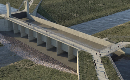
Despite the district’s national prominence, in September 1955, the Urban Redevelopment Authority of Pittsburgh approved the Lower Hill Redevelopment Plan. This plan called for the demolition of 1,300 Lower Hill structures and permanently displacing 8,000 residents. Where homes once stood, the city built the Civic Arena — the world’s first retractable-roof sporting venue — and Interstate 579. With the construction of the six-lane highway, the link between the Lower Hill District and downtown Pittsburgh was severed by a 12-m-deep (40-ft-deep) concrete canyon.
It took nearly 70 years to restore this broken connection. In 2019, the Pittsburgh Sports and Exhibition Authority set out to build a new sports arena to replace the aging Civic Arena. Included were plans for redeveloping the entire Lower Hill District and covering Interstate 579 with a new 1.2-ha (3-ac) highway cap park that would reconnect the district to Pittsburgh’s downtown.
Community-Driven Effort
As part of the design for the highway cap park, the city held extensive community engagement workshops and meetings with residents of the Hill District — the neighborhood next to the Lower Hill District — to elicit feedback on the project. Several key themes emerged. Hill District residents asked that the new park space emphasize
- connection — building a gateway celebrating the history and culture of the district;
- seating — allowing flexible space for future events;
- destination — creating a family-friendly atmosphere for daytime and nighttime entertainment, including spaces for food vendors;
- green space — incorporating sustainable landscape gardens with shade and ample open space;
- water — integrating interactive water features and considering ways to include children’s activities and education;
- and music — providing space for music and entertainment.
Using feedback from the workshops and meetings, the project team developed a final conceptual design, with a focus on green infrastructure and sustainable stormwater management.
Cap Structure
Detailed engineering design specifics of the highway cap structure are beyond the intent of this article. However, two unique aspects of cap structures are worth noting: the need to define appropriate design loading, and the critical importance of waterproofing for the structural elements below the soil.
Unlike a typical pedestrian or vehicular bridge structure, highway caps are not subject to design codes with specific loading guidelines. Designers must consider the details and intended use of the structure to establish appropriate loads and load combinations. These load combinations should include construction of the fill material, when large pieces of construction may directly load the bridge deck, as well as use of the green space after construction, including events space, a stage, or small buildings.
For the cap in Pittsburgh, park designers developed a landscape topography with fill depths ranging from 0.45 to 1.5 m deep (1.5 to 5 ft deep), so soil loads varied widely. Designers divided the cap into three separate bridges, each with one or two supporting piers, to limit span lengths and provide an economical structure.
To protect the structure below the fill, the project team installed multiple redundant waterproofing membranes over the bridge deck and down the integral backwalls at the abutments. For additional protection, the team covered these membranes with a 10-cm (4-in.) fiber-reinforced concrete protection slab, which prevents accidental damage that could occur during digging. Subsurface underdrains pull any excess water away from the top of the structure.
Stormwater Management
The highway cap structure effectively fills the gap over the highway and allows for a surface-level connection across the entirety of the park. The topography of the park site is sloped in a westerly direction, with a total elevation drop of 6.1 m (20 ft) and an average slope of 4%. This slope design was advantageous for conveying stormwater across the surface of the park. Based on this topography, it is helpful to visualize the park as three distinct stormwater management zones (see Figure 2, below).
Upper Gateway Zone.
Originally, the entire upper zone was a parking lot. The proposed park reduced the lot footprint and allowed for more park-user functionality. This area could provide food-truck access during community events or, potentially, serve as the future site of a permanent restaurant or entertainment venue. The upper zone also provides the main entrance from the Hill District side of the park, including a plaza area that serves as a performance art and gathering space with built-in terraced seating around the periphery. At the center of the plaza is a connected system of aesthetically designed stormwater trench drains. When it rains, stormwater flows toward the drains and then to the middle zone.
Middle Green Roof Zone.
The trench drains from the upper zone are daylighted within the middle zone as an open stormwater channel. Daylighting the infrastructure underscores the importance of water to park users. The open channel encourages visual and auditory interaction with the water as it descends a series of stepped concrete features and flows along a winding path that mimics a natural stream. The channel collects stormwater runoff from adjacent impervious sidewalks. An artistic concrete swirl at the bottom of the channel is a pretreatment vortex chamber. During rainfall, stormwater spirals around the vortex, so sediment and debris can settle out and deposit before the water enters a small drain and flows to the lower zone. The vortex feature serves a critical function as a pretreatment device, protecting the lower bioinfiltration rain gardens from sediment and potential clogging.
In addition, the middle portion of the park contains the highway cap lawn area that functions as a large green roof over the interstate. The lawn is approximately 3,200 m2 (0.8 ac) and is underlaid with an average of 61 cm (24 in.) of topsoil and 30 cm (12 in.) of gravel. Within the gravel is a 15-cm diameter (6-in.-diameter) perforated underdrain pipe system to drain the roof adequately during heavy rain when the held water exceeds capacity. The outlet of the underdrain connects to the bioinfiltration rain gardens. The lawn area has a total volumetric storage of about 790 m3 (28,000 ft3) and is capable of capturing approximately 15 cm (5.8 in.) of rainfall over its surface area.
Lower Bioinfiltration Zone.
The lower zone contains a series of six terraced bioretention rain gardens. The lower area manages the stormwater runoff from upstream impervious surfaces within the park. The uppermost terraced rain gardens receive stormwater from the green roof underdrain and the swirl vortex chamber.
Stormwater sequentially fills each terraced bioretention rain garden from the upper to the lower gardens. When the upper gardens exceed their volume capacity, stormwater overflows into the next-lowest rain garden. Once the lowermost garden is full, stormwater overflows into a domed beehive structure, where it is connected to an existing publicly owned sewer in the street.
Each bioretention rain garden consists of 15 cm (6 in.) of surface ponding area, 61 cm (24 in.) of high-performing engineered soil, and 30 cm (12 in.) of gravel. The six terraced rain gardens have a total volumetric storage capacity of 79 m3 (2,800 ft3), equivalent to approximately 4.8 cm (1.9 in.) of rain over the upstream drainage area.
The bioinfiltration rain gardens are located on preexisting soil, so they are not on top of the cap structure. Infiltration tests performed in the area below the rain gardens showed average infiltration rates of 7.6 cm/h (3 in./h). The project team expects that the rain gardens will be high-performing and naturally will drain between periods of rain without the need for underdrains. To date, there has been no clogging or excessive drain downtime in the gardens, which indicates they are operating as designed.
Landscaping and Signage
Landscape planting consists of more than 125 trees — 26 of which are large shade trees — and 2,000 native perennials. Designers placed trees on the periphery of the park to provide urban heat-island reduction and rainfall interception benefits as the canopy fills out and matures. Trees and shrubs on the cap structure consist of smaller, shallower-rooted systems to protect the integrity of the subsurface liner system. The bioretention rain gardens use native plants with high salt tolerance. Designers purposefully kept the plant palate simple, with five distinct species for easy identification by maintenance staff.
The park is named in honor of Frankie Pace, a respected community activist and head of the Hill District Community council during the era of forced displacement. Within the Upper Gateway Zone is a history storyboard educating park users about Pace and the history of the Lower Hill District. The park also features educational signage of a fictional child named Keisha, who teaches park users about the importance of culture, stormwater management, and environmental stewardship. Other inspirational signage throughout the park consists of seat plaques and low walls designed to spark curiosity about our natural world.
Bridge to Opportunity
A long list of partners supported the project, including the Pennsylvania Redevelopment Assistance Capital Program (Harrisburg), Pennsylvania Department of Transportation (Harrisburg), Pennsylvania Commonwealth Financing Authority (Harrisburg), Pennsylvania Department of Conservation and Natural Resources (Harrisburg), Allegheny County Sanitary Authority Pittsburgh), Sports and Exhibition Authority of Pittsburgh and Allegheny County, Urban Redevelopment Authority of Pittsburgh, Richard K. Mellon Foundation (Pittsburgh), Hillman Foundation (Pittsburgh), Heinz Endowments (Pittsburgh), and Colcom Foundation (Pittsburgh).
All partners understood the transformative potential of this project for the existing 9,500 residents of the Hill District. According to the 2013 U.S. Census, the Hill District has an unemployment rate of 21.2% and more than 2,000 vacant parcels, representing 53% of all parcels. Now, the park is literally a bridge to prosperity for job-seekers in the Hill, connecting them to the significant concentration of employment opportunities downtown.
"This is really a time to celebrate," said Pennsylvania Gov. Tom Wolf at the ribbon-cutting ceremony. "A great injustice was done in the 1950s, and this is finally, at long last, a way to address that injustice." The Urban Redevelopment Authority of Pittsburgh has stated that the project is building "critical infrastructure that will leverage further development, create jobs, and provide added opportunities to the greater Hill community."
New Urban Hubs
Frankie Pace Park serves as a national model for how to plan, design, and implement a highway cap park project in an urban community fractured by historical highway construction practices. The seamless integration of stormwater management features into the newly created park presented a unique opportunity to restore open space and construct resilient, sustainable community spaces with the future in mind.
Highway caps are at the forefront of the ongoing national equity conversation. In essence, these parks can achieve multiple objectives for the communities in which they serve, such as
- community gathering,
- honoring history and heritage,
- environmental stewardship,
- celebrating arts and culture,
- educating and inspiring future generations, and
- economic revitalization.
As cities across the United States look to build more highway cap parks, these principles should serve as a guidepost during initial discussions with the community. Most importantly, the people and historical context of the community should be at the forefront when designing the park space, with resilience, sustainability, and stormwater management as part of these conversations.
Water Environment Technology Digital